The Great Bend at Cooper's Point

It was under this guy's watchful eyes that I made my way up the Connecticut River to Cooper's Point yesterday. It was my first visit to the Pauchaug Boat Launch in Northfield since New Year's Day. Back then there was plenty of water in the river...this past Monday, not so much...just getting from the boat ramp to the river required finding a passage around the mud. Once out on the river the water was shallow and clear.
Shortly after paddling into New Hampshire I saw my first eagle of the day (an immature) atop one of the old railroad bridge piers...

Further upriver an adult eagle worked the eastern side of Pomeroy's Island...

The confluence with the Ashuelot River was very shallow...


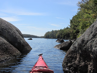
Approaching the great bend and Cooper's Point required walking my boat through shallows opposite and east of Stebbins Island.
Rounding the bend at Cooper's Point I found some deeper water and my first view of Vernon Dam...

Prior to the 1907 construction of the Vernon Dam which eliminated the natural falls here, this place must have possessed considerable mojo as well as having been the source for the early regional name "Squakheag"...

According to The History of the Town of Northfield (1875) by J. H. Temple and George Sheldon Native American name "Suckquakege" was applied by the natives to the fishing places near Cooper's Point and so to the village or clusters of wigwams in that immediate neighborhood. The authors make the case for the actual Native American name having been "Namaus-squam-aug-khige" which meant "a spearing place of salmon". The authors include an 1873 letter by John Stebbins attesting to the once bountiful fishery: "...Another company owned the fishing place at the foot of Stebbins Island (formerly Clary's). The mouths of the small brooks in this neighborhood, and the narrow pass at Elmer's Island, were famous places for spearing salmon. This was commonly done at night. A flaming torch was set in the bow of the canoe in which were two men, one to steer. They floated quietly down with the current, and the spear-man struck the fish as they were attracted to or blinded by the light." The letter also mentioned 75 bushels of fish being caught over two days at a spot a little downriver at Rock Island.
The rocky shore of Cooper's Point across from Elmer's Island...

Not a lot of fishing activity was seen by me on Monday, but imagine the surprise of the fellow who, while fishing below Vernon Dam, made this catch back in August of 2017 as related on this NOAA fisheries web site. That fish would have a tale to tell.
After landing back at Pauchaug I watched an unusual form of river dredging take place as this hungry machine drove straight into the river...

...gobbled up huge mouthfuls of Connecticut River mud and relocated them to a growing pile in the woods...


Comments
Post a Comment