Upriver to Menimesit

I'd previously paddled to where the "upper village" was located in Barre, MA, but the other two villages (lower and middle) had thus far eluded me. In another book, King Philip's War: The History and Legacy of America's Forgotten Conflict by Eric B. Schultz and Michael J. Tougias the authors refer to this historical place as follows: "Menamesit (sometimes Wenimessit) was perhaps the most important Native American military site of the war, and the site to which the Nipmuc fled immediately after the outbreak of hostilities in 1675." As to the actual locations, they provide a detailed description in relationship to Hardwick Road. I transferred their information to a map found on the Massachusettspaddler.com web site...

Shortly after passing under the abandoned Central Mass railroad bridge (now an unpaved rail trail)...


Thanks to the high water level I was able to paddle about 500 feet up the brook to a beaver dam not far from Hardwick Road...

The "lower village" was easily reached from the brook's bank...

Schultz and Tougias describe this village having been located on a "a flat plain of about 5 acres, bordered by the brook on one side... with the village about 20 rods from the Ware River." They also mention that the "site is marked by a small, inscribed stone on the north side of Hardwick Road just east of Wenimisset Brook." I found the old stone marker right where they said it was...


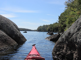
I left "lower village" and paddled out of the brook to the river where I resumed heading upriver towards "middle village". After paddling about a mile and through the narrow bend in the opening photo I got my first look at the elevated plateau where the village stood...

After landing and walking across the floodplain I reached the slope leading to the plateau. At the top I found the "the flat plain of about 40 acres" that Schultz and Tougias mention "stretching to the river"...

Seeing this flat and fertile expanse reminded me of another Native American village location visited this past June...Nanrantsouak (Norridgewock) on the Kennebec River in Maine...a very similar riverside plateau.
Just upstream from "middle village" is the dam and paper mill ruins at Wheelwright...

As recently as 1973 it was a thriving industrial site...today not so much...

On my return trip downriver I stopped for lunch at the old railroad bridge that once served this mill...


Before leaving these many abandoned entities I'd like to share this you-tube video by skyman2002 who captures the lonesome sound of a train horn echoing through the Ware River valley (especially at the end of his 3 minute video).

I'm about to finish reading "Our Beloved Kin" and therefore greatly appreciate your map of the location of two of the Menimesit villages and your sharing your visit to this area. It might interest you that some of the refugees also ended up creating the village of "Fort Hill" that is located in a large field by the Connecticut River Hinsdale, NH by the Vernon Dam. Unfortunately no one has so far been able to show me the location of this village.
ReplyDelete