Posts

Showing posts from September, 2019

Train Watching Eagle

Image
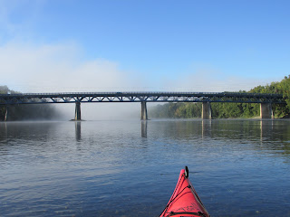
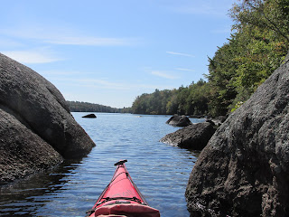
As the last of the early morning fog dissipated this past Friday, I paddled away from the Route 116 bridge in Sunderland, MA and headed up a very low Connecticut River.  The waters around the islands were particularly shallow.  Second Island, being in the middle of the river, basked in the sunshine... Third Island had a pair of ospreys at its south end and this eagle at the north end... The crook of a dead tree cradled a nest... In addition to being an avid paddler, I'm also a railfan and couldn't resist paddling a bit further to the double-track railroad bridge providing access to Pan-Am Railway's East Deerfield freight yard... My plan was to stop below the bridge in hopes a train might grace the structure.  I didn't have to wait long as the yard switcher began pulling a cut of cars towards the Montague side... While the switcher crossed and recrossed the bridge several times working the yard's east end, I found a spot on shore for my lunch

Highland Lake in Shoulder Season

Image
The fall foliage was an unexpected surprise when I paddled the 697-acre Highland Lake in Stoddard, NH this past Monday.  Being 2 weeks after Labor Day and a weekday, most cottages were unoccupied and their related watercraft secured to docks.  The lake is tributary to the Contoocook River's North Branch. A map of the lake found on the New Hampshire Fish and Game web site (public access maps for NH's 36 largest lakes) ... I launched at the south end... The lake's outlet is a short distance from the ramp.  The gatehouse there was being renovated... This long and narrow lake has more of a river-feel in places.  The wind (sw) was most noticed in the wider sections... ...whereas at the lake's northern end, things were quite serene... ...so quiet, in fact, that water could be heard tumbling through the rocks of this tributary... More signs of fall foliage... An osprey surveyed over a cove on the lake's east side... ...while this regal eag

Nubanusit and Spoonwood

Image
This past Friday delivered perfect conditions for exploring Nubanusit Lake and Spoonwood Pond's combined 718 acres located amidst the hills of Hancock and Nelson, New Hampshire.  The two bodies of water at an elevation above 1300' are joined at the hip so to speak, with a very short portage from one to the other.  They comprise the headwaters of Nubanusit Brook which flows down through Harrisville to Peterborough and the Contoocook River at an elevation below 700'.  I've long wanted to explore Nubanusit, perhaps due to its Native American name the meaning of which nobody seems to know for sure.  Some say it means "at the place of gently sloping banks", others say "small summer place", or "little waters".  However, the interpretation I favor is from C. Lawrence Bond in his Native Names of New England Towns and Villages .  Bond offers Nubanusit as meaning "at the wing shaped (pond)", showing "nuppoh" as the Native A

Running the Gamut

Image
Seems that's the way it's been the past week or so.  Everything from the above antique cocoaine bottle (found Tuesday in the Sudbury River) to a balloon... ... a bicycle...  ...a safe... ...a wallet... ...and an eagle that looked to have an injured talon... The balloon, bike, safe, wallet, and possibly injured eagle were all seen between Nashua and Hudson on the Merrimack River this past Friday the 13th.  Getting home from that paddle it occurred to me that John and Henry Thoreau might have been on that same stretch of river as they returned down the Merrimack in 1839.  Checked my copy of A Week on the Concord and Merrimack Rivers and found that they did, indeed, traverse the same stretch on September1839's Friday the 13th as the calendars for 2019 and 1839 are the same.  Of course they also covered close to 50 miles that same day from a starting point near the Merrimack's confluence with the Souhegan River all the way to their home in Concord, MA. 

Merrimack Tide Ride

Image
Returning to my Monday morning starting point I couldn't help but to wonder why I'd never paddled this stretch of the Merrimack River before...especially availing myself of a tidal assist.  I'd driven across the pictured Rocks Village Bridge just a little after sunrise some 6 hours earlier and launched at the Ferry Park launch in West Newbury, MA.  The tide was making its way upriver with another 2.5 hours till the scheduled high tide for Haverhill.  My plan: ride the tide up to Haverhill, take a break during the slack water, and then ride the ebb tide back down... So, off I headed paddling through the mist hanging above the water... Birds were up to greet the sun such as this osprey... ...and this blue heron... The deepest channel in the river is marked with navigational buoys (# 55 to #76)... ...and that's where the tidal boost was most effective.  Maintaining 5+ mph was easy with not a lot of effort. The bridge connecting Haverhill and Grovelan