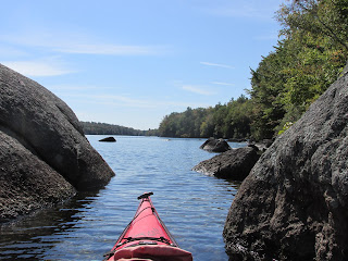
Nubanusit and Spoonwood
This past Friday delivered perfect conditions for exploring Nubanusit Lake and Spoonwood Pond's combined 718 acres located amidst the hills of Hancock and Nelson, New Hampshire. The two bodies of water at an elevation above 1300' are joined at the hip so to speak, with a very short portage from one to the other. They comprise the headwaters of Nubanusit Brook which flows down through Harrisville to Peterborough and the Contoocook River at an elevation below 700'.
I've long wanted to explore Nubanusit, perhaps due to its Native American name the meaning of which nobody seems to know for sure. Some say it means "at the place of gently sloping banks", others say "small summer place", or "little waters". However, the interpretation I favor is from C. Lawrence Bond in his Native Names of New England Towns and Villages. Bond offers Nubanusit as meaning "at the wing shaped (pond)", showing "nuppoh" as the Native American word for "wing" and "nusi" the word for shape. Spoonwood, being an English name, is easier to find as being another term for the Mountain Laurel plant.
With much of the shoreline protected from development these 2 bodies of water are special. Skicraft (jetskis) are prohibited from both. Additionally, gasoline motors are prohibited on Spoonwood.
Below is a map found at New Hampshire Fish and Game's web site (specifically Public Access Maps for NH's 36 largest lakes)...
The ramp is at the bottom of Landing Road. Parking is limited with numerous "No Parking" signs. On my arrival 3 pickups with boat trailers took up all of the spots on Landing Road. I parked on the next street up (Kings Hwy) and wheeled my boat to the ramp. There is a portable toilet there.
Headed north and west from the launch and after a mile or so found myself approaching the short portage to Spoonwood Pond (note the wooden stairs)...
Spoonwood is pristine...
Where Spoonwood bends to the south, Monadnock can be seen in the distance...
Once back in Nubanusit I passed this ancient looking stump (white cedar?)...
If only these roots could speak...
Moving to the western part of both Nubanusit or Spoonwood requires leaving Hancock and entering Nelson NH...
The view southwestward on Nubanusit...
Eventually I reached the outlet end where this gatehouse encloses the mechanisms for controlling the lake's level. According to a 1978 National Dam Inspection Report the first structure for regulating the lake's outlet was built in 1861...
It was on the paddle back to the launch that birds small and big were encountered. The little one...
...and the big one...
Before pulling away from the ramp I stole one last glimpse of this beautiful lake...
...which I feel fortunate to have experienced.
Because Nubanusit retains its Native American name to this day, I was surprised to find little mention of the people who called this area home before the Europeans arrived. In reading the History of Hancock 1764 - 1889 by William Willis Hayward I did find this one interesting mention: "Many traces of residence of the Indians may be found in the Town; but the first settlers found none here. I have been informed by A.S.Wood, that sometime after his grandfather had settled in town, on several occasions Indians from a distance visited him on their way to Mount Skatutahkee to procure certain plants of a medicinal nature to be found upon its sides. Who they were, and from whence they came, we know not, but doubtless they were the descendants of those who once roamed over our rugged hills and had their temporary homes in our beautiful valleys. The lakes and streams then swarmed with fish and an abundance of game was to be found on every hand."


Comments
Post a Comment