Eden of the Kennebec

"Eden of the Kennebec, - perhaps the Eden of Maine" were the words author and historian Justin H. Smith used to describe the section of the Kennebec River between Norridgewock Falls and Caratunk Falls. I came across his intriguing (to me) description in his 1903 book Arnold's March from Cambridge to Quebec. Smith's description combined with my desire to see first-hand the Native American petroglyphs on "Indian Rock" in Embden had me looking for a boat launch and campground along that stretch of river. Luckily I found both at the Evergreens Campground in Solon, ME...

... where this sign lets visitors know just how long folks have been setting up camp there...

Evergreens' location is ideal being right on the Kennebec's eastern shore, about a mile below Caratunk Falls. It's almost directly opposite from the petroglyph site and, according to the owners, some of Benedict Arnold's 1100-man expedition also camped here on their way to Quebec in October of 1775.
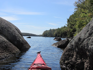
So, a week ago today, I pitched my tent there and began exploring a 12-mile stretch of the river. This old topo map shows the section of the Kennebec's "Eden" I paddled in both directions...

From the boat launch at the campground I did the upper portion between Gray Island's southern tip and Arnold's Landing at Caratunk Falls. For the lower portion I utilized the North Anson Boat Launch.
My first order of business on Monday morning was paddling across the river to the ledge (Indian Rock) bearing the Native American petroglyphs...


According to Edward J. Lenik's book Picture Rocks, American Indian Rock Art in the Northeast Woodlands there are more than 100 distinct designs pecked into this ledge of bedrock which juts out into the river. All of the images face downstream towards the south and would be encountered by upriver-traveling canoeists looking for a calm place out of the current where they could rest.
A moose and several canoes are seen on one section ...

Experts suppose that both the images and the actual rock itself were believed to possess supernatural powers.
Paddling away from the site I pondered how the Kennebec River for thousands of years served as a well-used transportation route within the Wabanaki world. Travelers in those long ago days used the river for travel in both directions, and portaging around obstacles was probably as natural for them as construction detours are for us.
However, today's river travelers can avoid the upriver work by taking advantage of a shuttle service offered by the campground for a reasonable fee. I gave doing so some thought, but eventually decided to forgo the shuttle and over the course of 3 days experience the river in both directions.
Caratunk Falls, at the upper end of the section, was reached by paddling against the current and as close to the shore as possible...

Gaining entry to the basin below the falls required passing through a narrow and shallow outlet where it was easier to line my boat rather than paddle it through.
Once in the large basin I was able to find the spot known as Arnold's Landing...

...where the army of men and boats left the river and began heading up the portage trail...

...which is about a half mile long.
The railroad trestle which once carried the Maine Central RR over the falls now serves ATV riders...

The view down at the gorge from the trestle...

Stone formations in the basin at base of falls speak to powerful forces once at play here...

From the basin's southeast corner the original course of the river leads south but today sees little flow...

...as the river was diverted to a southwest direction in the 1950s by this man-made straightaway to the Solon/Embden bridge...

Apparently this was done to help keep logs from going astray during the log drives which occurred annually until as recently as 1976.
The paddle/drift from here down to the southern tip of Gray Island (Burn's on old map) was effortless with only steering required.
The lower portion of the 12-mile section was explored using the North Anson Boat Launch on Madison St. as a starting point. Paddling around Savage Island brought me to the Kennebec's confluence with the Carrabassett River and ultimately to the Kennebec's main channel at this bank of sand and gray clay...

Most of the wildlife I'd see was encountered between this bank and Weston Island further downriver.
A loon...

Merganser and little merganser...

Eagles...


Including one on Wednesday morning that appeared to be drying out its wings following Tuesday night's heavy rains...

Osprey...

This hawk was watching over the most "Eden"-like spot I paddled into near Weston Island...

Flowers seen along the way...


Heading upriver to Gray Island required passing the stone abutments which supported the Patterson Toll Bridge between 1839 and 1926. The covered bridge here once connected Madison and North Anson...

Might this have been the last truck to pass over the bridge?...

Once past Patterson Bridge the river was shallower and the current stronger. Subsequently, I hugged whichever shoreline had the least current...much as I suspect the Arnold Expedition did with their bateaux. The slow progress allowed me to get a better look at whatever was lying on the bottom and eventually an old nail was found along the river's eastern shore...

Might it once have been securing the boards of a bateau?
Further along, a tree wore this old iron chain as a bracelet at its base...

Two saw-cut boards were found resting on the bottom. Both waterlogged to an almost sponge-like consistency...


Is it possible either or both came from one of those bateaux?
Eventually, after slowly working my way past a group of small islands where a dozen fly-fishermen were working the shallows, I reached my turnaround spot at the south end of Gray Island. After paddling against the current for 4 hours to reach this spot it only took an hour and a half to cover the same distance when going back to North Anson with the flow.
Before leaving the area I visited Norridgewock Falls and encountered this historical marker at the appropriately named Arnold Lane...

Driving a mile down Arnold Ln brought me to the foot of the falls. The photo below shows the view looking upriver towards the falls. Arnold's Expedition is believed to have begun their mile plus portage on the river's west side from close to this spot...

About a half mile downriver from here is where the once significant Native American village of Nanrantsouak was located. Last summer I paddled up the Kennebec River from Oosoola Park to the village site. A link to that post.
Driving homeward on Route 201 I stopped at the Robbins Hill Scenic Vista between Solon and Skowhegan and found this plaque telling the story of the Old Canada Road...


Comments
Post a Comment