Posts

Showing posts from November, 2018

Assabet/Nashoba Rare Treats

Image
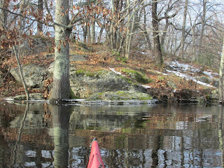
On the Saturday following Thanksgiving I paddled up to Egg Rock and found the inscription completely submerged.  I also noted the rivers were surprisingly ice free considering the record-cold temperatures of late.  So, with an urgent need to work off some turkey and all the fixin's, I began ascending the Assabet River. Our very wet autumn has resulted in river water aplenty which helped to keep most of the usual obstacles submerged... Before I knew it my modest expectations were exceeded and I'd reached the river's confluence with Nashoba Brook.  Entering this significant tributary to the Assabet was made easy by the raised water level.  It was smooth paddling upstream under the Old Colony railroad bridge, the pedestrian bridge, and along the stone wall past Nashoba Bakery... In all of my previous trips this would be the point where the water would become too shallow for further paddling.  However, on this occasion I rounded the bend and found myself approaching

Nashaway Bridges

Image
Approaching Nashaway's "meeting of the waters" just above Center Bridge where the Nashua River's North and South branches converge, I was cautiously optimistic the South Branch might be navigable.  All of my previous attempts in ascending the branch have been thwarted by the many fallen trees at the confluence.  However this past Monday, thanks to the bountiful amounts of rainfall we've received of late, I was able to float over those fallen trees and ascend the first half mile of the South Branch.  Doing so allowed me to reach and paddle under the historic Atherton Bridge which is about a quarter mile upstream of the confluence... A closer look at Atherton Bridge from upstream... The bridge is listed on the U.S. National Register of Historic Places as a wrought and cast iron Post-type pony truss bridge...   The town of Lancaster (originally Nashaway Plantation) has two iron truss bridges, the Atherton built in 1870 across the South Branch and the P

Upriver to Menimesit

Image
The day was cool, cloudy, and showery as I paddled against the Ware River's steady current this past Monday morning.  My motivation to paddle this stretch of river resulted from reading Our Beloved Kin: A New History of King Philip's War by Lisa Brooks in which she places her three main historical characters at Menimesit, a Native American (Nipmuc) stronghold.  In the 1675-1676 time period Menimesit consisted of three separate villages along the eastern bank of the Ware River in New Braintree, Massachusetts. I'd previously paddled to where the "upper village" was located in Barre, MA, but the other two villages (lower and middle) had thus far eluded me.  In another book, King Philip's War: The History and Legacy of America's Forgotten Conflict by Eric B. Schultz and Michael J. Tougias the authors refer to this historical place as follows: "Menamesit (sometimes Wenimessit) was perhaps the most important Native American military site of the wa

October Hodgepodge

Image
The Massachusetts Central Railway locomotive rumbling across the swift flowing river confirmed that I was right where I wanted to be on the next-to-last day of October...on water flowing through the center of my state.  It's a place where this river's shores have provided refuge in the past.  To my surprise, other than the train and a few otters, not another soul was there. The smaller print on the locomotive (above the word "Massachusetts") reads "The Ware River Route" and the train was doing just that... following the Ware River from South Barre down to Palmer, MA. I too would follow the river, but only down as far as the dam at Wheelwright.  The conditions encountered were representative of what I saw during most of October...plenty of water, more clouds than sun, and a rarely absent breeze.  The usual October show of colorful foliage was, for the most part, muted... Some of the better October foliage I did encounter was on the Contoocook Riv