Posts

Showing posts from August, 2019

Isle de Plastique

Image
While paddling with the tide up the Merrimack River yesterday I landed on a small island to stretch my legs.   In doing so I noticed a fair bit of empty plastic containers, literally, at my feet and within a 25' radius of my landing spot... In looking closer my eyes began to detect even smaller pieces of plastic... ...not much bigger than the adjacent yellow bottle cap.  The plastic wafer-like disks are actually high-tech "BiofilmChip M" plastic carriers... ...manufactured for use in wastewater treatment where, according to their manufacturer, "They are designed to provide a large protected surface area for the biofilm and optimal conditions for biological activity when suspended in water."  One cubic foot of these wafers provides 1200 square feet of surface area for biogrowth attachment.  Prior to March 6, 2011 the wafers were doing just that at a wastewater treatment facility located some 40 miles upriver on the Merrimack in Hooksett, NH... until

Machias Bay Rendezvous

Image
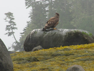
Fog, gold-tinged sea weed, a pair of immature eagles, harbor seals, terns, and the call of loons...all in my first 20 minutes out on the water. I found myself in a special place...one I had to visit after reading reading Edward J. Lenik's 2002 book Picture Rocks: American Indian Rock Art in the Northeast Woodlands.   In his book I came across this account:  "Seasonal gatherings involving more than one hundred canoes loaded with Indian visitors took place at Machias Bay as late as the 1790s.  European settlers reported that the sounds of drumming could be heard through the night."  That account piqued my interest.  Further research brought me to George W. Drisko's 1904 Narrative of the Town of Machias  in which Drisko wrote  "The late Charles Gates,of Machiasport once said to the author,: "I have heard my mother say that when a girl, 1785 '90, I counted over one hundred birch canoes drawn up on the beach and shore opposite Machiasport, while the Ind

The Great Bend at Cooper's Point

Image
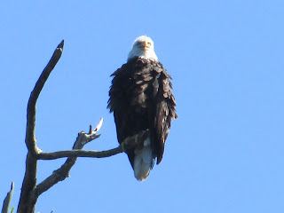
It was under this guy's watchful eyes that I made my way up the Connecticut River to Cooper's Point yesterday.  It was my first visit to the Pauchaug Boat Launch in Northfield since New Year's Day.  Back then there was plenty of water in the river...this past Monday, not so much...just getting from the boat ramp to the river required finding a passage around the mud.  Once out on the river the water was shallow and clear. Shortly after paddling into New Hampshire I saw my first eagle of the day (an immature) atop one of the old railroad bridge piers... Further upriver an adult eagle worked the eastern side of Pomeroy's Island... The confluence with the Ashuelot River was very shallow... ... with gravel bars best suited for these killdeers... Approaching the great bend and Cooper's Point required walking my boat through shallows opposite and east of Stebbins Island. Rounding the bend at Cooper's Point I found some deeper water and my fi

Summer's Spell

Image
Some ideal summertime conditions of late have afforded this paddler many enjoyable hours out on the Concord, Sudbury, and Assabet Rivers.  These are the paddling trips I'll most remember come next winter.  Some images from them: The cat's eyes...or the bridge just below the Faulkner Dam at Talbot Mill in North Billerica (opening photo). The weathervane atop the mill's cupola... The tepee frame at a shady Ralph Hill Conservation Area... The remnants of a previous bridge which once spanned the Concord River near Route 3A in Billerica...  Fordway Bar just before Talbot Mill... A heron trying to beat the mid-90s heat... A white-tailed deer that stopped feeding long enough to take a peek near Clamshell Bank on the Sudbury River... June's bountiful rain must have helped in producing this grand mushroom near Fairhaven Bay... ...and this vibrant flower near Heaths Bridge... The blossoms of the button bush are everywhe