Machias Bay Rendezvous


I found myself in a special place...one I had to visit after reading reading Edward J. Lenik's 2002 book Picture Rocks: American Indian Rock Art in the Northeast Woodlands. In his book I came across this account: "Seasonal gatherings involving more than one hundred canoes loaded with Indian visitors took place at Machias Bay as late as the 1790s. European settlers reported that the sounds of drumming could be heard through the night." That account piqued my interest. Further research brought me to George W. Drisko's 1904 Narrative of the Town of Machias in which Drisko wrote "The late Charles Gates,of Machiasport once said to the author,: "I have heard my mother say that when a girl, 1785 '90, I counted over one hundred birch canoes drawn up on the beach and shore opposite Machiasport, while the Indians were in Camp Fires, phullabaloos and dances, in the forest growth and woodlands on the East side and towards Holmes Bay."
Additionally Drisko mentions another historian saying "Machias River, when first inhabited by white settlers was, and appeared to have been a long time back, a place of Rendezvous by the various tribes of Red men, who came in September of every year, from the East as far as St. John, and from the West as far as Penobscot, to associate in war dances and campfires."
If all that wasn't enough there's also Lenik's mention in Picture Rocks that "Machias Bay provides the longest chronological series (ca. 3,000 to 380 years ago) as well as the largest number of known sites (nine) and the largest number of petroglyphs (five hundred plus)". Lenik also quotes Mark Hedden, an archaeologist with the Maine Historic Preservation Commission, who"suggests that attributes of these ledges, perhaps a quality of light or position in the known world, made these sites particularly attractive."
All of the above suggested to me that these waters, shores, and islands possess significant mojo.
So two Sundays ago I drove to scenic Down-east Maine and set up camp at Cottonwood Camping and RV Park in Columbia Falls. From there I'd head east each morning passing along the way the Town of Machias' namesake falls...


The following showery Monday morning I launched into the waters of Holmes Bay in Machiasport which placed me within striking distance of the areas mentioned for the large seasonal gatherings...

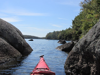
I paddled south about a mile and a half to Hog Island. Upon landing there...

On my return trip, and after paddling less than a quarter mile from the island, I found myself having no visual points of reference and needed to place my complete trust in compass/gps. It had been quite awhile since I last paddled in thick fog and this was only the fourth time I'd ever needed to rely on an instrument.
On Tuesday morning the fog had been swept away and replaced with a blue and cloudless sky...ideal conditions for exploring islands further to the southeast...

Before leaving the rocky beach I noticed a large group of unattended boats...

I paddled past Long Point and then across upper Machias Bay to a ledge near Salt Island where this strange boulder seemed perched to capture the sun or perhaps the moon...

On an islet off of Salt Island sea lavender was growing out of the rocks...

The view from Salt Island to the south and Bucks Harbor...

Along Salt's southern shore was a cove with Caribbean-colored water...


Heading towards Birch Point this view of the Gates House and the mouth of the Machias River...

Birch Point at nearly high tide...

These waters also hosted what was quite likely the first naval battle of our country's Revolutionary War back in June of 1775. It was just off little Round Island...

Machias Bay was a place I could've spent many more days exploring. Oddly, I didn't see any of the petroglyphs...perhaps due to my looking for glyphs in all the wrong places. By that I mean my eyes were always looking horizontally when I later learned I should've been looking downward to the ledges closest to the low water line. Oh well, I'm guessing the petroglyphs were looking up at me.


Comments
Post a Comment