Finding Fifteen Mile Falls

In the opening photo we paddlers are feeling a tad small as we approach the Samuel C. Moore Hydro Station (blt.1957) said to be New England's largest conventional hydroelectric plant.
The other behemoth, Frank D. Comerford Hydro Station (blt. 1930), sits 8 miles downriver...

While paddling the two reservoirs (Comerford and Moore) created by these dams paddlers can only imagine how the river might have looked before 1930. Besides examining old maps, one can get some idea of what the Fifteen Mile Falls were like by reading this article Log Drive on the Connecticut by Robert E. Pike which appeared in The Atlantic magazine July 1963. The author describes the last big log drive on the Connecticut River which took place in 1915 and describes the hazardous nature of a riverman's job. Regarding those unfortunate men who succumbed to the hazards he says "On the Penobscot, rivermen buried their dead comrades where they found them, hanging their spiked boots on tree branches over their graves. At Mulliken's Pitch, at the foot of the Fifteen-Mile Falls on the Connecticut, they used to bury rivermen in empty pork barrels. When the New England Power Company built the great dam precisely at the Pitch in 1930, it excavated half a dozen of these makeshift coffins, the old spiked boots still intact."
Regarding the actual harnessing of the falls for hydroelectric generation, this article by Paul Chouinard (which appeared in The North Star Monthly) provides a wealth of information regarding the actual construction of the hydro project. His article also includes old photographs providing a sense of just how big a project this was starting a year or so before the Great Depression.
Our group had it relatively easy in comparison to the rivermen of old. No diet of salt pork, baked beans, gingerbread, and molasses for us. We took it easy doing day paddles from our base camp at Crazy Horse Family Campground in Littleton, NH. This kept our boats nice and light and relatively easy to heft around. Our fleet consisted of 2 canoes and 3 kayaks. The crew pictured below...

On Day 1 we explored Moore Reservoir from Cozy Nook Road in Gilman, VT down to Moore Dam and the Pattenville Boat Launch (about 10 miles)...

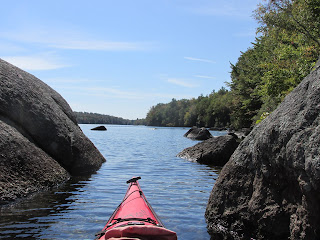
Heading down the reservoir...

Along the way we passed this relic perhaps from the 1950's...

Nearing Moore Dam some of the White Mountain peaks came into view...

After checking out the dam and hydro station we landed at Pattenville.
On Day 2 we explored the Comerford Reservoir launching from a nicely protected cove at Pine Grove Boat Launch on the Vermont side...


Before heading upriver to Moore Dam we paddled over to Comerford Station...


A bit larger than the pump impellers I used to work with.
We also got our first look at what lies on the other side of Comerford Station Dam...

Once back on the water we paddled up the length of the reservoir and against a strengthening current as we neared Moore Dam...

Then it was a turnabout and paddle back down to Pine Grove...

After leaving Pine Grove and driving along Route 5 in East Barnet, VT we passed a collection of old railroad cars and engines. After paddling 14 miles that day I could relate to this particular piece of equipment...

Some of the railroad equipment stored at East Barnet may be left from the days when a 4-mile section of railroad served an essential role in the building of Comerford Dam. There's some mention on the internet of a "Fifteen Mile RR" that was operated by the New England Power Company.
On Day 3 four of us decided to paddle from Comerford Dam down to McIndoe Falls...


After launching into the fast-moving current and sneaking-in a last look back at the dam...

Nonetheless, we got a brief look at the scenic village of Barnet, VT...


The McIndoe Hydro Station (also part of the hydro project, but smaller than the other two dams) was releasing a good amount of water...

We'll tackle the stretch below McIndoe on a future trip. All of the dams visited by us are presently owned and operated by Great River Hydro
We enjoyed good fortune over the three days including finishing up and breaking camp before the black flies decide to start biting.


Comments
Post a Comment