Waters Beyond the Mohawk Trail

With a goal of paddling some Hoosic waters, I researched the river and stumbled upon the book The Hoosac Valley: Its Legends and Its History written by Grace Greylock Niles published in 1912. In this book I read the riveting story of Fort Massachusetts and how it came under attack in August 1746. It's a story I wasn't previously aware of and, therefore, on my drive along the Mohawk Trail, I made a point to pull into the shuttered-up Price Chopper parking lot in North Adams, MA and visit the spot where the frontier fort once stood. Not much there today...just a chimney which was a replica of the original...


The fort had been built in 1745 in hopes of thwarting French and Indian incursions upon the Connecticut River towns in Massachusetts. Interestingly, no one bothered to legally purchase the land from the Mahican people who owned it. Some poor staffing decisions resulted in the fort being left in a most vulnerable state with only about 20 men to defend it, and half of those men were sick. Naturally that would be the exact time that a combined force of 740 French regulars and 470 Indians arrived via the Hoosac Valley from Canada (guess "Murphy's Law" existed even back then). Somehow, despite being grossly outnumbered, these few defenders successfully held-off the attackers for 27 hours until a lack of ammunition compelled them to capitulate and accept the French commander's terms of surrender. Those terms resulted in the fort being destroyed and the 30 or so survivors being escorted as captives to waiting prison cells in far-off Canada. The journey had them retracing the route the attacking force had taken overland through the Hoosac Valley to the Owl Kill trail then northward to Whitehall at Lake Champlain's southern end. Once on the lake they traveled the rest of the way to Canada in sailing canoes. The fort's minister, Rev. John Norton kept first-hand notes on the journey and they were later published as "The Redeemed Captive".
To reach the portion of the Hoosic River I planned to paddle, I'd be driving basically the same route those captives traveled: Route 2 west through Williamstown, route 7 north into Pownal, VT, Route 346 from Pownal to North Petersburgh, NY, Route 22 north through Hoosick, Hoosick Falls, and North Hoosick to the area where Owl Kill enters the Hoosic River from the north. One of the most scenic stretches of my drive was passing through the valley in Pownal where the Dutch influence was noted...


It took 2 days for Norton and his fellow captives to march alongside the Hoosic River the approximately 25 miles between Fort Massachusetts and the confluence of the Hoosic River and Owl Kill located at today's Eagle Bridge, NY. They camped somewhere in this vicinity before leaving the Hoosic and heading north via the Owl Kill Trail.
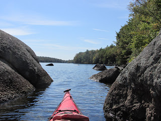
I drove to roughly the same spot and decided to launch into the Hoosic a few miles downriver at Buskirks Bridge (also opening photo)...


Reaching Owl Kill required paddling through some shallow and quick moving water at the Eagle Bridge...


After passing under Eagle Bridge I briefly entertained thoughts of paddling further up the Hoosic until reaching the much stronger current beneath the old Delaware and Hudson Railroad trestle...


In The Hoosac Valley: Its Legends and Its History the Owl Kill Trail is frequently mentioned. It seems to have been an important crossroad of sorts. Travelers arriving from the north could either go west down the Hoosic to the Hudson River, southeast to the Hoosac Valley, or east to the Walloomsac River and Bennington, VT. Even today rail lines branch-off in those same directions. French and Indian forces from Canada entered the Hoosic Valley en route to southern New England. It is also the point where the captives from Fort Massachusetts left the valley and followed the Owl Kill en route to Lake Champlain. Thirty years later during the American Revolutionary War British General Burgoyne dispatched a sizable force under Colonel Baum to seize supplies at Bennington, VT. Baum's troops marched up the Hoosic past Eagle Bridge to Hooksick Junction where they followed the Walloomsac River to their ultimate defeat about 6 miles to the east of Eagle Bridge.
After my visit to Owl Kill I paddled back down to Buskirks Bridge where I continued further west in the direction of the dam at Johnsonville...

This stretch of the Hoosic was moving slower and had numerous sloughs where herons and egrets were plentiful...


Ospreys and an eagle were also seen.
Launching at Buskirks afforded me access to an 8 mile stretch of the Hoosic and provided glimpses of both its shallow/quickwater and deeper/slower characteristics. Two web sites that provided helpful paddling information were the Hoosic River Watershed Association and Massachusetts Paddler.com
The day I paddled (8/7) was a scorcha and thunderstorms moved across the area an hour or so after my paddle. When I returned to my campsite at Pine Hollow Campground in Pownal, Vt this little fellow was on my tent's threshold...

While in the area I also visited the Bennington Battlefield (actually located in New York state)...


Nice blog post! :) To learn more about the history of Fort Massachusetts, visit the website of the Friends of Fort Massachusetts -> https://sites.google.com/site/friendsoffortmassachusetts/
ReplyDelete