Staking Out the Sebasticook

By the time I reached the suspected location the fog had burned off and the shallow water above the weir was as smooth as glass. I slowly paddled back and forth across the area straining my eyes in hopes of seeing some of the 600 plus documented wooden stakes. While I didn't actually see them, I'm fairly confident they're down there...rising up out of the lake-bottom beneath my boat's hull. The stakes might never have been discovered if not for an excessive amount of nutrients having developed in the lake. In an effort to reduce the concentration of nutrients, the lake was partially drained in 1991 and it was then that the stakes were exposed to viewing. Some have been dated back to more than two thousand years before our present time.
I spent an hour or so in the vicinity of the weir and, before leaving, noticed an immature eagle was keeping a watchful eye over the place...

Eagles are a common sight on the Sebasticook these days as I discovered earlier in June when I paddled the lower 3 miles of the river above Fort Halifax and encountered many. Over the past 10 years migrating anadromous fish are finding much easier passage up and down the river thanks to dam removals and fishways such as this one at Sebasticook Lake's outlet...

The Sebasticook River also played an important role as a travel route for humans in times past. In a 1960 Bulletin of the Massachusetts Archaeological Society (Vol. 21) I came across this statement "Thus the Sebasticook was a main water highway of ancient travel and the principal route by which French missionaries communicated with one another in the area they were working. Connecting the Penobscot with the Sebasticook route was a short carry of some 40 rods in Levant between Swadapscook and Kenduskeag streams now connected by a channel". This route of travel is also attested to anecdotally by this 1812 account of an impending Indian attack described in William H. Mitchell's A Brief History of Newport, Maine, 1814 - 1914 ; "A few days later the Indians came by way of the Stetson Stream, one hundred and fifty strong, and camped on Birch Point (Barrows Point). Two citizens, with a flag of truce, volunteered to go and interview them and ascertain their intentions. During their absence the citizens took down the old flintlock muskets, the women saw to it that the kettles were filled with boiling water and all preparations were made for a brave defense. The two volunteers returned and reported that the chief said they were of the Penobscot tribe and had fled from the St. John tribe, with whom they had had trouble, and the Penobscots thought the St. Johns were coming over to fight them. These Indians spent about ten days trapping and hunting in the vicinity and then departed down the river. Their mode of travel was by way of the Kenduskeat Stream to Stetson; carry across to Stetson Pond (Pleasant Lake); thence to Great East Pond (Sebasticook Lake) and so on to the Kennebec; this was the Indian highway between the two great rivers of Maine, and from it originated the name of Newport, so called because it afforded a portage for the Indians in their route to and from the Penobscot and the Sebasticook."
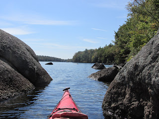
Before leaving Sebasticook Lake I entered and paddled a short way up the Stetson Stream before emerging back onto the lake and seeing this view which would have greeted travelers en route to the Kennebec...

The following morning I drove to the downriver town of Pittsfield and launched into the Sebasticook River at Peltoma Bridge...

I picked this location to launch because the Sebasticook flows through the Big Meadow Bog here and also one mile above the bridge is the confluence where the East and West branches diverge...

On the advice of this fellow...


Wildflowers were also on display...

After almost 2 miles I reached a riffle at what I believe was Peltoma Point. This was said to have been near the place where the sachem Peltoma lived out his days according to the "Legends of Peltoma Point" found on the web site of Snakeroot Organic Farm.
Returning to the confluence I next headed up the East Branch and was struck by how different the two branches are from one another. The East Branch is wider and deeper with stately white oak trees along its banks...

The current is hardly noticeable and the overall conditions are apparently ideal for bryazoan colonies such as these...

The difference between the two Sebasticook branches reminded me of similar differences between the Sudbury and Assabet rivers as they diverge from their confluence in Concord, Massachusetts.
Ospreys seemed established here...

While the paddling through Big Meadow Bog was easy going, finding good and solid places to land..not so much. I started looking for such a place to stretch my legs and was surprised with how far I needed to go before finally finding one. Once on terra firma I started a short climb up the bank when a loud snort got my attention and I saw the white flag of a deer bouncing off into the trees. I figured that would be the last of any deer sightings here...but the deer continued snorting from a distance and that's when I noticed some fellow deer seemingly fascinated by my presence...


Their curiosity satisfied, they turned and bounded off into the woods. Fortunately for them I wasn't part of a traveling band with hungry stomachs to fill.
Other than one kayaking fisherman, I saw not a soul while in the Big Meadow Bog. These days most travel through the Sebasticook Valley is done via the adjacent Route 100 or the railroad line running to the river's north.
On my way back to Newport I stopped in Pittsfield where this retired Maine Central Railroad caboose wiles away the days next to the old train station...

Once back at my base of operations at the Lake Sebasticook Campgound in Newport the sound of train horns and slow-moving diesel locomotives echoed through the valley as I walked in search of supper. Suppose it only fitting that this train enthusiast would have his meal temporarily delayed by the passage of a long freight train heading from Waterville to Northern Maine Junction (near Bangor)...

When the last car disappeared around the bend...


Comments
Post a Comment