A Confluential Place

As one who's very fond of exploring river confluences I recently spent two days paddling the waters of Maine's Merrymeeting Bay. As the above map shows Merrymeeting provides a plethora of confluences and, conveniently, they're all concentrated in a basin measuring roughly 7 miles long by 3 miles wide. In addition to two tide cycles each day, the bay receives waters from 6 tributaries. Of these the most senior is the Kennebec River (whose waters emanate from Moosehead Lake) entering at the map's top right (above Swan Island). A close second is the Androscoggin River (whose waters emanate from New Hampshire's Umbagog Lake) and enter at the map's bottom left by Mustard Island. Add four smaller rivers into the mix: Abagadasset, Cathance, Eastern, and Muddy, let them all mingle a bit until the ebb tide allows their exit through the narrow outlet known as "Chops" and onward the remaining 17 miles to the Gulf of Maine.
Samuel de Champlain, one of the first Europeans to see the bay, upon entering it in July 1605 wrote the following: "Pursuing our route, we came to the lake, which is three to four leagues in length. Here are some islands, and two rivers enter it, the Quinibequy (Kennebec) coming from the north-north-east, and the other (Androscoggin) from the north-west..."
While Champlain referred to Merrymeeting Bay as a "lake" modern definitions are more complicated. Wikipedia calls it "a large freshwater tidal bay....but not what is usually meant by the word bay." Maineencyclopedia.com calls it "a broad expanse of water". However the definition I liked best was found on the Friends of Merrymeeting Bay's web site: "Formed by the confluence of six rivers, including the Kennebec and Androscoggin, Merrymeeting Bay is the largest freshwater estuary system north of Chesapeake Bay; it drains an astounding 38% of Maine's fresh water. Biologically the Bay is classified freshwater tidal riverine and geologically, an inland delta."
I started my floating exploration of Merrymeeting at Fort Richmond Park on the Kennebec River...

The little river town of Richmond was seemingly still asleep as I arrived at around 7:30 am. Had I arrived back in August 1724 the historic Fort Richmond would have been bustling with activity as a force of 208 colonial soldiers in 17 whaleboats prepared to head up the Kennebec River to the Abenaki village at Norridgewock . The Massachusetts Provincial government had placed a sizable bounty on the scalp of the Jesuit priest Father Rales who ministered to the village and whom they believed inspired Abenaki raids upon the English settlements. After murdering and scalping Father Rales and many Abenaki women and children, this force returned downriver with many bloody scalps to redeem for payment.
Fast forward another half century to September 1775 (five months into the American Revolutionary War) when this same spot was jumpin' once more as it witnessed the passage of a 10 ship flotilla of schooners and sloops carrying some 1100 soldiers of the newly formed continental army en route to capture Quebec City from the British. This force was under the command of Benedict Arnold and included a 19-year old Aaron Burr who, according to legend, wooed the Abenaki princess Jacataqua who is said to have accompanied them to Quebec. I think it would be fair to say that at this point the 1100 men had no idea just how difficult the mission they had undertaken would become over the next several months.
At any rate my kayak was the only boat getting underway from Fort Richmond on this peaceful May morning, and I headed downriver along the west side of 4-mile long Swan Island. Settlements on Swan Island were abandoned in the 1930s and today the island contains the Steve Powell Wildlife Management Area managed by the Maine Dept. of Inland Fisheries and Wildlife. Access to the island is by ferry from Richmond.
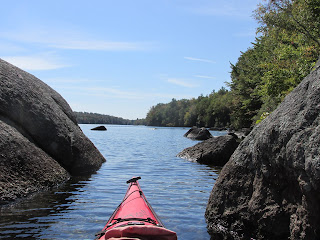
The section of the Kennebec River below Richmond I paddled through was once known as "Sturgeon Alley" according to Kerry Hardy in his book Notes on a Lost Flute (A Field Guide to the Wabanaki). Once past the Swan Island Point, I got my first good look at Merrymeeting Bay...

I was tempted to paddle across to the "Chops" but knowing the tide had turned I stopped at Twing Point and began my return trip. This time I stayed to the immediate east of Swan Island and the experience was splendid in regard to eagle sightings. There were both mature and immature eagles...


...as well as an eagle in a nest...

There were numerous little pocket beaches and near the upper part of Swan Island I reached Little Swan Island ...

...and the Lovejoy Narrows where the Kennebec's strong currents were on display...

After pushing around the upriver end of Swan Island I swung downstream to a now awake Fort Richmond...

I don't think one could find a more pleasant paddling destination than a simple circumnavigation of Swan Island starting from Richmond. Sweet!
After another night in my tent at the Augusta/Gardiner KOA in Richmond I was up early the next morning and driving to the opposite end of Merrymeeting Bay where the Androscoggin River enters. In Topsham I stopped at this dam about 5 miles upriver from my intended launch site...

Under cloudy skies I launched from the end of Bay Bridge Road in Brunswick where there was once a bridge across the Androscoggin at Mustard Island...

Again not a soul around at 8 am and I got underway with the intention of reaching "Chops" at slack water. Along the way I saw more eagles and passed by this one idyllic (to me) camp...

Soon and right on schedule for slack tide I approached Sturgeon Island...

...and behind it the "Chops"...

After passing through "Chops" I entered Goose Cove where the waters of all six rivers were fully combined and getting a lot saltier. The cove was totally calm and looked that way downriver to Lines Island...

Here I turned about and paddled back through the "Chops" and across the Kennebec and the mouth of the Abagadasset River to Bald Head on the bay's west side where an early lunch was taken...

Following the bay's western shore brought me past where the Cathance River enters...

En route to my starting point at Bay Bridge Rd I passed around a picturesque Pleasant Point...

...where yet another eagle perched sentry...

Had I been at this spot on June 13, 1722 I'd have witnessed a flotilla of 20 canoes carrying 60 Abenaki warriors according to George and Henry Wheeler in their History of Brunswick, Topsham, and Harpswell, Maine and the Ancient Territory known as Pejepscot published in 1878. The warriors were looking to avenge the first colonial raid on Norridgewock.
In paddling around the Androscoggin's Mustard Island I got a closer look at the bridge remains on the island's west side...

...thus completing my exploration of Merrymeeting Bay.
Before returning to my base camp I decided to visit the site of the failed 1607 English colony at the mouth of the Kennebec River, Fort St. George. After driving down to Popham I found signs for Popham Beach and Fort Popham but nothing that mentioned the failed colony. In exploring Fort Popham I did encounter a plaque showing a general location for Fort St. George. Made one final attempt in that direction down a dead-end road and voila... stumbled upon the colony's location...

The site was re-discovered in the 1990's and matched a detailed map of it drawn by John Hunt and found in Spain in 1888. These plaques tell the story...


I can't help but wonder what the Fort St. George colonists thought of Merrymeeting Bay. Somehow, I get the impression they felt safest when close to the sea and much less so when further inland.
Earlier in my trip to Maine and while waiting an additional day for more favorable tides I explored some of Pleasant Pond and the connected Cobbosseecontee Stream. The name is said to mean in Abenaki "plenty of sturgeon". Pleasant Pond was ...well, quite pleasant...

...and while I encountered no sturgeon there were plenty of loons...

The Cobbosseecontee joins the Kennebec River in Gardiner, Me...

...where a beautiful waterfront park tells the story of the town and its waterways...

I liked the trail markers...

Two signs near the waterfront served to remind me that we still know how to mend things...


Comments
Post a Comment