Spirit of Metichawon

In the early 1700s the regional sachem of the Potatuck tribes, Waramaug, maintained a residence at Metichawon. In Benjamin Trumbull's History of Connecticut (1818), the Rev. Daniel Boardman described Waramaug as follows: "That distinguished sachem, whose great abilities and eminent virtues, joined with his extensive dominion, rendered him the most potent prince of that or any other day in the colony; and his name ought to be recorded by the faithful historian as much as any crowned head since his was laid to rest in the dust". Waramaug's longhouse was said to have been located on the west side of the river where he could both see and hear the falls. Europeans referred to this longhouse as a "palace" and in Samuel Orcutt's The Indians of the Housatonic and Naugatuck Valleys (1882) Rev. Daniel Boardman's son Sherman provided this detailed description: "...built by his subjects, in token of their gratitude to him, about two years before his death. The ediface was built in the Indian style and was about one hundred feet in length, and about twenty in breadth, covered with bark curiously wrought and embellished with portrait painting, done by the greatest artist. I have been informed that he had a great friend and brother Sachem in the North who, like Hiram, sent with his message cunning men who, with others were employed in collecting materials and erecting the building. Many of those barks were carried five or six miles on the backs of numbers selected for that purpose. The paintings were arranged in the following order of state; first the King and Royal family, Counsellors, Judges, etc. In other apartments were drawn every kind of four-footed beast, flying birds, and creeping things, down to the ant and covey-fish, all drawn much to the life."
In Lover's Leap State Park near the believed location of Waramaug's "palace" is a plaque displaying this representation of a longhouse...

It's said that when Waramaug died in 1735 he was buried per his request on Falls Mountain so that he could look out upon Metichawon. If true this might be his view...

Near the place from which I launched my boat, a modern-day artist created this mural which seems to depict Metichawon and possibly the sachem Waramaug...

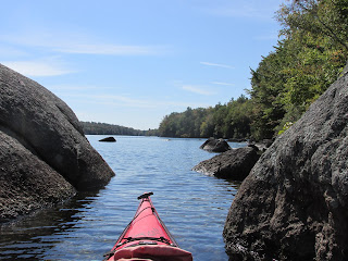
After launching, I entered the cove and approached the opening into the gorge...


Up to this point it was fairly easy to imagine this place as it once might have looked. However, back when it was Metichawon, the water level was about 14 feet lower and the gorge's rocky bottom would have been exposed. The walls of the gorge would have reverberated with the ever increasing roar of the now-submerged and silenced falls. Just before reaching the falls two bridges span the gorge...

The first bridge dates to 1895 and is a wrought-iron through lenticular truss bridge built by Berlin Iron Bridge Company.
Just beyond the more modern (vehicular) bridge I noted the small whirlpools indicative of the turbulence occurring 14 feet below the water's surface...the original falls...

The great numbers of migrating fish began declining starting in 1877 when the Housatonic River was dammed downriver in Derby. The falls were finally erased completely in 1955 by the building of Shepaug Dam which created Lake Lillinonah (the second largest lake in Connecticut).
The area of the gorge is today within Lover's Leap State Park where there are several informative plaques. One shows a 1910 post card depiction of the falls...

About two miles upriver from Metichawon was the main village of Weantinock. Like Metichawon it was located at the base of a hill...

Whereas the hill (Falls Mtn) at Metichawon provided water teeming with fish and eels at its base, this hill (Fort Hill) offered a large and fertile plateau below it where Native Americans found sustenance for hundreds of years. Seems appropriate that it was Earth Day weekend that I was seeing these two examples of how Mother Earth provides. I was also struck by these two hills having very similar profiles.
When this land was sold to European settlers the Native Americans moved another 8 miles upriver to Schaghticoke where one of the earliest Indian reservations in America was established in 1728 with 2400 acres of land at Schaghticoke Mountain. Over the years the state of Connecticut, acting as "caretaker", sold off all but the 400 acres that remain today. The Schaghticoke Tribal Nation is currently suing the state in hopes of being fairly compensated for this land.
Paddling the stretch the Housatonic between Spooner Island and Kent, CT allowed me to see how only the most rugged land on the river's west side was preserved for the tribe...


What struck me as most egregious was that today's Schaghticoke Reservation has no actual frontage on the Housatonic River as a narrow strip of land at the mountain's base was taken for a roadway. In looking for a place to launch my boat I came across an online application in which the Schaghticoke Tribe was seeking to gain access to the Housatonic River for recreation and fishing. There's more than a little irony in their having to ask permission to access their own ancestral homeland.
While enjoying a lunch break in a slough I found myself under the watchful eyes of this guy...


Perhaps he got a whiff of my salmon in a pouch lunch.
Hydro projects at Bulls Bridge create some impressive falls...


The small covered bridge itself...

While on the river at Schaghticoke and later at the Bulls Bridge area I encountered students and staff from the South Kent School conducting a trash clean-up...

...which was great to see and inspired me to fill my dry bag with empty plastic containers over the course of my visit to the Housatonic River.


Comments
Post a Comment