Paddling Pequot Waters

It being early spring and mid-week afforded me the sense of having these places pretty much to myself. Most of the other boats I saw were out of the water and encased in shrink-wrap. The multitudes of boat slips were for the most part unoccupied.
Paddling down the Mystic River I did encounter Stonington Crew getting in some practice...

Mystic Seaport was viewed from the water...


Then it was under the Mystic River Bridge...


I went down as far as the picturesque village of Noank...

...and almost to the Morgan Point Lighthouse...

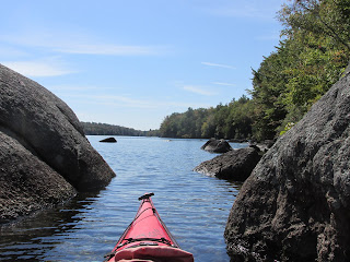
Then it was time to head back upriver where I was able to locate Porter's Rocks near Old Mystic...

However, the English vessels proceeded east only as far as Narragansett Bay where they enlisted the help of the Pequot's Native American neighboring rivals (Mohegans, Narragansetts, and Niantics). This combined English and Native American force now numbering several hundred then marched overland to Porter's Rocks where the English commander Captain John Mason later wrote his men bivouacked a few hours using the rocks for pillows.
At 1:00 am Mason woke his men, marched 2 miles to the fort where he divided the 77 Englishmen into two groups...one led by him and the other by Captain John Underhill. The plan was for the English soldiers to simultaneously enter the fort from its two entrance points while their Native American allies surrounded the fort's outside perimeter. Mason's group, however, was detected and the Pequot warriors awoke to find English soldiers inside the fort and entering wigwams. Close-quartered fighting ensued among the clustered wigwams and what next occurred has been a matter of controversy ever since. Captain Mason decided that rather than continue close-quartered fighting "we must Burn them" and set the wigwams on fire. Captain Underhill did the same at the opposite entrance and the fire consumed the many wigwams. The results were horrific with all but a handful of the occupants being either shot, stabbed, or burned to death.
Some English historians and clerics (at the time) called it a valiant battle, while others called it a massacre noting that innocent women and children had been killed. The historian, Richard Anson Wheeler, who in 1900 wrote The History of the Town of Stonington, decided to make the case that no women or children were living in the fort since Captain Mason made no mention of such in his written account. Wheeler goes even a step further in saying "His (Mason's) object in burning the wigwams doubtless was to drive the Indians from their hiding places in and about their wigwams, so as to bring them out into a fair open hand to hand fight." Consequently, a statue of the 'heroic' Captain Mason was erected on the spot where the fort is believed to have stood. The statue remained there for 107 years until the Pequot Tribe was successful in having for it removed (relocated) in the 1990's. In its place today stands a tree the Pequots call "the tree of life"...

I can only conclude that historian Wheeler deliberately chose to ignore the written account of Captain John Underhill who was also at the fort that fateful morning. Underhill in his account wrote "but seeing the fort was to hotte for us, wee devised a way how wee might save our selves and prejudice them, Captain Mason entering into a Wigwam, brought out a fire-brand, after he had wounded many in the house, then he set fire on the West-side where he entred, my selfe set fire on the south end with a traine of Powder, the fires of both meeting in the center of the Fort blazed most terribly, and burnt all in the space of halfe an houre; many couragious fellowes were unwilling to come out, and fought most desperately through the Palisadoes, so as they were scorched and burnt with the very flame, and were deprived of their armes, in regard the fire burnt their very bowstrings, and so perished valiantly: mercy they did deserve for their valour, could we have had the opportunitie to have bestowed it; many were burnt in the Fort, both men, women, and children..." Underhill also wrote "We had sufficient light from the word of God for our proceedings."
Thanks to the first-hand accounts of Mason and Underhill, along with Wheeler's History of Stonington and Battlefields of the Pequot War (Mashantucket Pequot Museum), one can flesh out most of the locales involved.
The following morning I launched into Little Narragansett Bay from Barn Island and paddled over to the mouth of the Pawcatuck River where I, once again, picked up Captain Mason's trail. At the conclusion of the Pequot War in September 1638 the remaining 180 Pequots were divvied-up among their former rivals. The Mohegans were given 80, the Narragansetts 80, and the Niantics got 20. The Pequots were told they were no longer Pequots and could never live again in their former homeland.
Captain Mason, thinking his mission complete, returned to his home in Windsor, CT.
However, it was later discovered that a group of Pequots escaped captivity and resorted to living free again at a place called Massatuxet along the Pawcatuck River in Westerly, RI. Wheeler describes the location as being "about three and one-half miles north of Watch Hill, where they built a wigwam village and planted adjoining lands with Indian maze or corn." The Connecticut Colony dispatched Mason and 40 soldiers in a shallop to "supplant" this illegal Pequot settlement. Mason's men were accompanied by the Mohegan sachem Uncas and 100 of his warriors in 20 canoes.
It's my belief, based on Mason's narrative and Wheeler's information, that they and I were heading to the same destination, first the mouth of the Pawcatuck River...


At the river's mouth there's plenty of room for all of our vessels. I imagine it would've been quite a site...Mason's shallop with 40 soldiers onboard, accompanied by 20 canoes each containing 5 Mohegan warriors...all heading upriver with not the best intentions. As long as I'm imagining I might as well include a Dutchman who preceded all of us..Adriaen Block whom Block Island is named for. Block aboard his vessel "Onrust" (meaning "Restless" in English) entered this same river in 1614 and was the first European to map it as far as Pawcatuck Rock.
Mason's force found the small Pequot village situated on the eastern side (perhaps near Mustuxet Cove) but was unable to land his "bark" there due to shallow depths. Therefore he landed on the Pawcatuck Rock side and, from the sound of his written account, used the Mohegan canoes to get him and his men across the narrow gap at Pawcatuck Rock to reach the village...

Interestingly, the Englishman who did the translating for Captain Mason, Thomas Stanton, must have seen something he liked about this place. According to Wheeler, Stanton returned there in 1651 and built a Trading Post at Pawcatuck Rock ..."for the reason that the deep water channel touched the east side of said rock, where vessels trading with him could easily receive and discharge their cargoes without any expense for the erection of a wharf."
Getting my boat close to the rock I'd agree with it being a natural wharf...

My guess is the fishing must have been great at this narrow pinch-point as well
On my last day in the region I decided to visit the above-tidal section of the Pawcatuck River launching a little below Bridge Road in White Rock village (Westerly, RI)...

My goal was to paddle upriver to the river's confluence with the Ashaway River near Potter Hill. Thanks to the removal of the White Rock Dam in 2016 it was possible for my boat and I, like a herring, to do just that. Along the way we passed the still occupied White Rock Mill bldg...

And looked back at where the dam and mill raceway once stood...

Paddling around Bumpin Hill and Mount Moriah brought me to where I entered the Ashaway...


Around the next bend are the remnants of the Potter Hill mill complex...


Just past the mill is the dam with a fish ladder to left side...

At this point I turned about and let the swift/steady current carry me back downriver to my takeout.
On this day I noted very little trash in the river. One exception was this Styrofoam cup that once contained what I'm told is local favorite java brand...

As I write this I'm recently informed that the Pawcatuck River and 6 of its tributaries were this past March 18th designated with "Wild and Scenic" status. Congrats to those who endeavored in the effort and also congrats to those who worked on removing the dam at White Rock.


Comments
Post a Comment