Posts

The Little Bridge At Last

Image
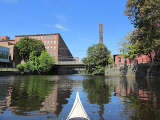
Certainly not the most impressive bridge I've paddled to and under but it did prove the most elusive.  Many times I'd tried to reach the footbridge (above) but on each previous occasion one too many beaver-built obstacles persuaded me to abort short of reaching the bridge.  However yesterday, the Tully River's generous water levels convinced me to make, yet another, attempt.  From the north end of Long Pond I proceeded further north and ascended a horseshoe-shaped beaver dam near the overhead power lines.  It was then I heard voices and, soon after, encountered two paddlers heading downstream.  When asked how far they'd made it they answered "to the footbridge" and that was all it took to inspire my pushing onward.  The two paddlers looked familiar and it occurred to me I'd paddled with them before (later in the day I'd encounter them again near the river's confluence with Lawrence Brook)... At the second encounter I'd surprise myself (an...
Busted Dam at Damon Mill

Image
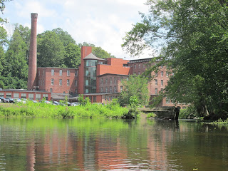
For many years paddlers wishing to traverse the Assabet River through West Concord, MA have been confronted with a broken dam at the Damon Mill (pictured above in 2017).   Not anymore as the old broken dam has been removed (photo below taken 10/20/18)... While driving along Route 62 the other day I noticed something different out of the corner of my eye.  Turned around, drove into the parking area behind the mill, and found the dam is no more... The river passing by the mill is now at least twice and, more probably, three times as wide as it formerly was. The old view looking upriver... Yesterday's view upriver... Most that paddled through the old narrow opening will remember this rock formation that lurked in about the middle of the passageway... Thanks to the work of an excavator that was still on site, the need for dodging the rock has been greatly reduced.   With the demolition equipment still there, I suspect the broken dam was onl...

Upper Valley Rendezvous

Image
It's been a long time since I last slept on the ground when camping, and I confess to having become quite accustomed to the comfort of a cot inside a spacious cabin tent...aka "car camping".  When a friend, Erik, mentioned a multi-day paddling/camping trip on the Connecticut River's Upper Valley section, I wondered if I'd be able to handle "roughing it" once again.  In joining canoeists Conrad, Erik, Bill, and Jonathan (above) this past Columbus Day weekend I put my smallest tent and sleeping pad to the test. We launched from beneath the Route 302 bridge in Woodsville, NH and, before beginning our downriver trip, paddled a short distance upstream to where the Ammonoosuc River passes beneath the Bath/Haverhill Covered Bridge before its confluence with the Connecticut... The confluence of the Ammonoosuc and Connecticut rivers played a tragic role back in 1759 during the French and Indian Wars.  According to this sign located 2 miles downriver and a...

September's Balance

Image
The balancing act of the immature male wood duck (above) served to remind me of how balanced my September paddling was between old haunts and new waterways. One beautiful late summer afternoon on the Sudbury River in Lincoln, MA this white-tailed deer kept its eyes closed and seemed to be drinking it all in... On the Nashua River at Petapawag a heron locked in deep thought... A few unusual containers were encountered such as this old bottle peeking out from the Assabet River's muddy bank in Stow, MA... ...the mud perhaps helping to preserve it in pristine shape... ...or possibly it was the staying power of Clorox bleach. This small container floating down the Assabet and also in Stow, MA might be worth a few bucks... Usually seeing a Dunkin Donuts container means Styrofoam or plastic.  Not in this instance however... ...with this rugged and re-usable container found in the Concord River in Concord, MA. With September being a month of transition a few t...

Deception at Cochecho Falls

Image
This past Monday after a pleasant and tide-assisted paddle up the Cochecho River, I found myself nearing the end of tidewater in Dover, NH.  Expecting a waterfall I became a little concerned upon seeing only a huge brick building on my left and a wall of solid rock on my right... However, entering a portico on my left brought me under the brick building to where the falls and fish ladder came into view...  ...paddling a little further revealed more of the fall's majesty... A good bit of water has flowed over the falls since the arrival of Europeans in the 1600s.  However, it was not far from this spot that one of the most unusual and disturbing events of King Philip's War occurred some 350 years ago.  On a September day in 1676 gathered on a field near the falls were approximately 400 Native Americans (many being women and children) and approximately 200 English soldiers.  Historical accounts are all over the place in describing the events that unf...

August in the Rear View

Image
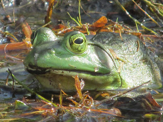
Flipped the page on the calendar before launching into the Assabet River at Ice House Landing in Maynard this past Saturday.   With the new month of September now underway I couldn't help but  reflect on the most excellent August I can remember.  Water levels remained high enough to allow access to Fort Meadow Brook where the above bullfrog enjoyed this view of the old trestle... One theme of this past August was the generous amounts of rain resulting in easy access to otherwise hard-to-reach places.  For example, back in the middle of the month I was easily able to paddle past the above trestle and witness this Fort Meadow Brook osprey nest... August's high water levels also allowed me to ascend the Tully River's first mile above its confluence with the Millers River in Athol.  My reward...this view of Little Tully Mountain... On the Sudbury River, passage beneath the Old Town Bridge and looping back to the river's main channel was a viable o...